Showing posts with label trade. Show all posts

Monday, July 20, 2009

One perspective on the pyschological landscape of Modern China

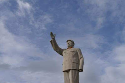
Image of Mao Ze Dong from Lijiang, Yunnan Province, China.Dear Gentle Reader,

The social contract in modern China is something like this:

We, the State, provide you, the Worker, with the privilege of the opportunity to make more money; we grant you economic liberties.

In return, you, the Worker, agree to not seek other liberties, or to cause unrest which would perturb the equanimity of the State.

Chinese people, the Workers, have largely accepted and signed onto this social contract in modern China.

And, all good contracts need enforcement clauses.

The following are images that one sees if one dips off the tourist routes onto the locals' pathways, onto the traveller's routes.

Apart from troubled regions, where the social compact appears to be crumbling, or where parties feel that the other side's fulfillment of the bargain has not been maintained, these images are not intended as a show of force per se; they are intended as a reminder of the potential enforcement mechanism, should it be required.


Image of a heavily armed PLA (People's Liberation Army) solider.

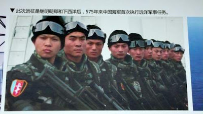
Image of a naval team found in Shenzhen's domestic air terminal, Guangdong Province, China.Image of a PLA special forces unit in China.
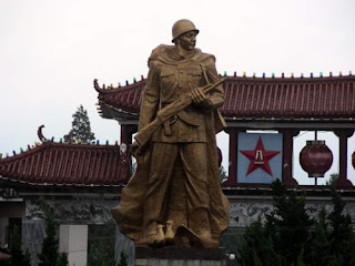
Image of the symbol of a military garrison located in the centre of a major tourist destination in China.

Image of regular People's Liberation Army soldiers going to daily guarding duties in Yunnan Province, China.

Image of the State, China.


Tschuess,
Chris

Monday, June 29, 2009

Signal Tower at Blackhead Point, Hong Kong

Image of Signal Tower, on top of Beacon Hill, from outside our window, here in Hong Kong.Dear Gentle Reader,

The external walls of our apartment are, basically, windows.

This spells good news for potential defenestrators.

It also provides poor Pommes, your Hero, with a view on the world that he can no longer play in.

Depending on how long you have been visiting here, you have seen the title view of this post.

Image of Signal Tower, on top of Beacon Hill, seen from higher up in our building, here in Hong Kong.If I go a bit farther up my building, that view changes.

One day I wondered what this building was.

Being a scribe, I went looking for what other scribes might have written and filed about this place.

It turns out that this is Signal Tower and that the outcropping of rock that it stands upon is called Blackhead Point.

In the heyday of frigates and clippers, in Hong Kong's early mercantile culture and history, Signal Tower was very visible and very important.

And, I discovered, the most important piece of Signal Tower was taken down for its constituent metal sometime after 1933.

Everyday at 1 pm, from 1907 to 1920, and twice a day, at 10 am and at 4 pm, from 1920-1933, a large copper ball, situated upon a tall, vertical rod mounted on the top of the building, was released and plunged down to the top of Signal Tower.

After this operation, the copper ball would be slowly winched back up to its resting place in time for its drop, again, the next day.

What was this big copper ball for?

It was a once-a-day (later a twice-a-day) timepiece that ships in the harbour could see and set their chronometers by.

Why was it there? First, a digression.

Hong Kong Island was won by naval arms. Hong Kong Island was ceded by treaty, in 1841, to Britain from China's Imperial Qing Dynasty Emperor.

Hong Kong not only relied on the British Navy for security and projected naval power, but, Hong Kong was the way station for opium on its way into China, and for goods, such as silver, gold, silk, and teas, on their way to Britain, Europe, and the Americas.

Hong Kong, though an International Free Port, nonetheless had many ways of generating revenue and profits off traders and it depended on international shipping which mean frigates, and, much later, steam vessels. And shipping vessels depend on knowing where they are, and what direction they have to head, to get to their markets to sell their wares.

An image of an old frigate in Hong Kong's Victoria Harbour
Signal Tower might have been the third signal tower in Hong Kong. The Signal Tower near my house replaced a less visible signal tower on the Kowloon waterfront built in front of the Tsim Sha Tsui Police Station by 1884. I don't know when that tower was built, but Kowloon was not ceded to the British until 1860 after China's defeat in the Second Opium War

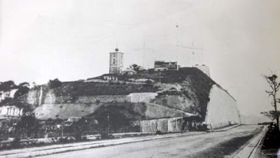
Signal Tower, on Blackhead Point, used to look like this, and you can clearly see the big copper ball on the roof...

Image of the old Signal Tower, built in 1907 on top of Beacon Hill, in Hong Kong.
So, why was knowing the time important? Why was this Signal Tower, with its time signal, important?

To note location, even today, on a map, people talk about the longitude and latitude of that location.

If you imagine the Earth as being a sphere with the North Pole pointing up, and the South Pole pointing down, then latitude are the horizontal markings that slice the world up.

[So the equator (latitude 0), the Tropic of Cancer (23° 26' 22" north of the Equator), the Tropic of Capricorn (23° 26' 22" south of the Equator), and the Arctic and Antarctic Circles (respectively 66° 33' 39" north and south of the Equator) are all latitude lines.]

For Reference, Hong Kong is just below the Tropic of Cancer.

Latitude (in the Northern hemisphere) was easy to calculate if you could find a star close to the North Pole. (It was also easy to tell if you could see the sun at high noon.)

Polaris, the North Star (the one which the handle of the Big Dipper points to), stays within 1° of the North Pole. So, mariners would use an astrolabe or a quadrant or a sextant or an octant to determine how many degrees the horizon was from Polaris (or, in the day, the sun at meridian height, but there is no need to get too technical here).

The number of degrees that the horizon would be from Polaris indicated to the mariner how many degrees of latitude north of the Equator she and her vessel were.

The difficult measurement for the mariner to make was longitude, which measures how eastward or westward you are on a map.

Longitude lines are the lines that cut the earth into vertical slices; all longitudinal lines cross through both the North and South Pole, so Polaris is not a good reference because they all longitudinal lines intercept it.

To determine longitude, besides a rather tricky and math and algorithm intensive lunar reckoning system, the mariner had to know the time. With the time, and a few simple readings, the mariner could easily work out where she was, and which direction she needed to sail in to get to her destination.

Each ship would have, for safety and redundancy, three ship's clocks to allow the crew (or rather one, designated, privileged Master Mariner) to tell the time and work out how far east, or west, around the globe they were on the travels.

The ship's three clocks were kept in bottles, on gimbals, in the heart of the ship to protect them from the elements and the motion of the sea and the ship.

But, still, the duress of life at sea, and the shocks of repeated hits of waves on the bow and sides of the ship, was rough on timepieces, and chronometers necessary for voyages measured in months needed to be checked for accuracy.

Many coastal cities have daily guns, but light travels faster than sound, and that is why Hong Kong had the big brass ball on Signal Tower at Blackhead Point.

Not so witty or pretty, but I look at this tower everyday, and now I finally know its purpose and import. Which is good enough for me, today.


Tschuess,
Chris

Monday, June 22, 2009

Tuen Mun, A city contained...

Image of a rusted container with a 'Transamerica Leasing' leasing logo on it.
Dear Gentle Reader,

The Korean War was active from 1950 to 1953, but, it never really ended.

An armistice was signed in 1953 though peace was never declared.

Further, North Korea recently declared its withdrawal from that armistice on May 27, 2009.

But, this article is not about a home for peace, or war, on the Korean Peninsula, or anything on the Korean Peninsula.

It's not even about the Korean War, except tangentially.

This post is tangentially about the Korean War as the Korean War saw the first great growth of metalized containerisation for shipping.

The USA found that metal containers, instead of wood, once standardized, were harder to destroy, more difficult to pilfer from, and quicker to load, unload and transport.

With these insights, CONEX, the CONtainer EXpress project of the USA's Department of Defense, began and thus the Korean War marks the dawn of modern containerisation (as opposed to the twilight of (wooden) transport containerization which started in the late eighteenth century; it was a long twilight, baby).

Nineteen years after the start of CONEX, 1972, in turn, saw the dawn of containerisation in international, civil (as opposed to military) trade in Hong Kong.

In 1972, the first dedicated container ship to arrive in Hong Kong, the Tokyo Bay, docked in Kwai Chung.

By 1975/1976, container cargo was already accounting for 51% of the total dead weight tonnage of cargo exported or imported in the world (today more than 90% of non-bulk cargo is shipped via containers).

By 1980, Hong Kong had eclipsed Osaka, Japan, to become the third largest container port in the world.

By 1987, Hong Kong had eclipsed both Rotterdam, the Netherlands, and New York, USA, to become the number one container port in the world.

Of course, when those containers aren't being shipped out, they sit empty.

Idle.

And land is not cheap in Hong Kong, as your humble scribe found out when looking for a container for his life, and the belongings of the Hero and the Heroine.

Image of stacked, empty containers in Tuen Mun, Hong Kong.Containers that are not filled with goods to be shipped frequently end up in Tuen Mun, a suburb city of a half million people outside of Hong Kong.

Tuen Mun started off its days as defensive gate city (channel gate is what Tuen Mun translates to).

Tuen Mun formed a defensive channel to stop foreign threats; not that it was ever effective against non-Chinese threats, like the British...

But, now, all threats to Tuen Mun are contained...

For, you see, Tuen Mun is where many of the unused shipping containers sit.

Recently, China's export trade has dropped by over 26% in dollar terms. That represents a lot of containers.

This means that the number of containers sitting idle has grown...

Second image of stacked, empty containers in Tuen Mun, Hong Kong.
So, some are used in novel ways.

Like this lovely house,

Image of a house made of containers.
with a carport, and a covered garage/workshop (the landscaping, admittedly, leaves much to be desired, but it is low maintenance).

Image of a carport and garage made of containers.
Some structures, of course are more downmarket.

Image of a container rancher with room to grow, for a growing family, and space for a dovecote for those avian fanciers...

Image of a container shack/hunting blind (in Tuen Mun). A fixer-upper in need of some TLC, but perfect, already, for back-to-nature unabomber types...Some structures are almost hillbilly market (or hillybilly, as the Heroine likes to say).

While others are more mid-market.

Image of a two-story walk-up container unit with shade and a back yard (in Tuen Mun, Hong Kong). Perfect for growing families. Must be seen to be believed.
The flip side of reduced trade is, apparently, increased housing.

And I have long thought that much housing, in Hong Kong, is simply containerization of people.

Now, in Tuen Mun, my suspicions have been confirmed.


Tschuess,
Chris

Postscript

Speaking of containers, and Tuen Mun, my mysterious scholarly Buddhist reader (but never commentator?) in California would likely not forgive me if I didn't mention Pui To.

And, having seen the tools that Buddhism reserves to use against its enemies (go back into the archives...) ...I want to stay on the right side of Buddhists...

So.

The great Buddhist missionary, Pui To, arrived in Tuen Mun in 428 AD in his own drinking cup, transformed into a vessel for travelling the drink (the waterways of the Pearl River Delta).

(In comparison, I drink and travel, or travel and drink, but rarely do I travel my drink. Your humble scribe is so déclassé...)

Pui To, however, did more than experiment with containers (drinking cups) and their efficacy as travelling objects.

Pui To, as a very devout Buddhist, would go to the local markets, buy live fish destined for the kitchens, and release those same live fish back into the water.

Further, the fish that never made it back to their watery homes, the dead ones, well, Pui To would inter these fish in specially constructed mausoleums... ...architectural containers to hold and memorialize the dead. (Why? Because Buddhists generally respect all life as sacred.)

So, Tuen Mun has not only had a long history, but has had a long relationship with containers transformed.